Sloaros (til Langvatn)
| Marking: |  |
Difficulty: | Very demanding |
| Distance: | 6.1 km | Status: | Closed |
| Round track: | no |
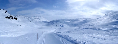

At the pass Hardingskardet with view in the direction of Hovden
Foto: Jan Mielke
Foto: Jan Mielke
Back to the overview map
Løypa prepareres f.o.m. vinterferien t.o.m. 2. påskedag.
Dersom det observeres reinsdyr i løypetraseen kan løypa stenges på kort varsel og være stengt i minimum tre dager.
Track statististics
| Altitude difference: | 194 m | ||
| Lowest point: | 1045 m | Highest point: | 1239 m |
| Vertical meters up: | 393 m | Vertical meters down: | 393 m |
| Steepest up: | 23.8 % | Steepest down: | 23.8 % |
| Longest up: | 1490 m | with a altitude difference of 105 m | |
| Longest down: | 2374 m | with a altitude difference of 105 m | |
| Incline/Decline | >15% | 10% - 15% | 5% - 10% |
| Up | 508 m | 449 m | 2535 m |
| Down | 448 m | 428 m | 2616 m |
| Plane (±4%) | 5262 m |