Vidmyr
| Markering: |  |
Nivå: | Lett |
| Lengde: | 6.2 km | Status: | Åpen |
| Preparert: | 05.04. 13:40 |
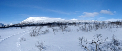

Utsikt fra Vidmyr løypa mot Nos
Foto: Jan Mielke
Foto: Jan Mielke
Tilbake til oversiktskart
Løypestatistikk
| Høydeforskjell: | 85 m | ||
| Laveste punkt: | 816 m | Høyeste punkt: | 901 m |
| Høydemeter oppover: | 119 m | Høydemeter nedover: | 121 m |
| Bratteste oppover: | 18.2 % | Bratteste nedover: | 20 % |
| Lengste oppover: | 826 m | med en høydeforskell av 34 m | |
| Lengste nedover: | 1175 m | med en høydeforskell av 72 m | |
| Stigning/Fall | >15% | 10% - 15% | 5% - 10% |
| Oppover | 34 m | 218 m | 770 m |
| Nedover | 88 m | 130 m | 687 m |
| Flatt terreng (±4%) | 4186 m |