Maurli
| Marking: |  |
Difficulty: | Medium |
| Distance: | 4 km | Status: | Open |
| Round track: | no | Groomed: | 07.04. 14:21 |
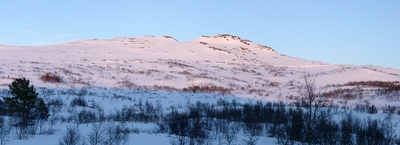

View from the Maurli trail to the Geiskeli trail in the evening
Foto: Jan Mielke
Foto: Jan Mielke
Back to the overview map
Track statististics
| Altitude difference: | 316 m | ||
| Lowest point: | 768 m | Highest point: | 1084 m |
| Vertical meters up: | 369 m | Vertical meters down: | 53 m |
| Steepest up: | 69.2 % | Steepest down: | 42.2 % |
| Longest up: | 1685 m | with a altitude difference of 162 m | |
| Longest down: | 74 m | with a altitude difference of 3 m | |
| Incline/Decline | >15% | 10% - 15% | 5% - 10% |
| Up | 620 m | 862 m | 1362 m |
| Down | 167 m | 52 m | 0 m |
| Plane (±4%) | 939 m |